Sailing in Lake Oroville, California
Lake Oroville Dam itself is a marvel. At 770 feet in height and taller than Hoover Dam
(Hoover Dam is 726.4 feet high). Lake Oroville is the highest dam in the United States.

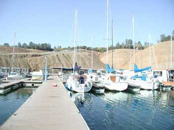
Bidwell Marina is the home of a number of happy sailors and sail boats.
When full, Lake Oroville Dam stands at 900 feet above sea level and has a shoreline of 167 miles and 15,500 surface acres.
In Dec. 2002 the water level fell to 690 feet, which is 210 feet below the crest. That was the third lowest level in Lake Oroville's history.
The record low was 645 feet above sea level in 1977.
The newest concrete launch ramp goes down to 702 feet.
The dam stands an impressive 770 feet high and is 6,920 feet long at the top (note that Hoover Dam is
only 1,244 feet wide).
Lake Oroville is the main storage facility for the California State Water Project and is the nation's largest state built multi-purpose water development project. The lake reservoir is the second largest in all of California and is only surpassed by Lake Shasta which is in the Federal Central Valley Project.
Lake Oroville's water goes to Southern California as well as a diversion of the lake is to flush salt water
when it threatens periodically to encroach too far into the Sacramanto-San Joaquin Delta. The Delta water quality
is constantly monitored and if the salinity goes too high then some of Lake Oroville's water is dumped in order
to flush the salinity.
No other lake in the region experiences water level volatility like Lake Oroville's.
Lake Oroville's recreation area provides a lot of recreational opportunities such as camping, swimming, hiking, boating, and both bike and horseback riding along the many trails around the lake. Houseboats can be rented and there are numberous floating campsites available on Lake Oroville.

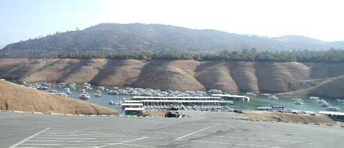
In Oct. 2002 Lake Oroville's water level was very low

Note how low the water level was

Bidwell Marina Dec. 2002 when the water level was at 210 feet from the top

Here is the ramp at 145 below the top of the dam.

Bidwell Marina area at 33 feet from the crest of the dam.

Looking on to the (read "no") parking lot from Bidwell Marina
at 7 feet from the crest (May 19, 2003).
From Bidwell Marina to:
Berry Creek = 12.0 miles
Bloomer's Ravine Creek anchorage = 6.5 miles
Concow Creek = 15.5 miles
Enterprise Bridge = 6.0 miles
Feather Falls view point = 11.0 miles
French Creek = 14.0 miles
Goat Ranch = 8.0 miles
Lime Saddle Marina = 11.5 miles
Poe Dam = 17.0 miles
Ponderosa Dam = 8.5 miles
Potter's Ravine anchorage = 3.0 miles
Spring Valley Gulch anchorage = 9.5 miles
Sycamore Cove = 4.0 miles
Oroville Dam was finished in 1968, creating the main storage site for the State of California
Water Project and provides relief from floods in areas below the dam, including the city of Oroville.
The dam stopped the salmon run in the South Fork of the Feather River because the fish can't get past the dam to spawn.
The dam also destroyed one of the best small-mouth bass fishing areas, from Riverbend Park up to the middle and north fork of the Feather River.
Sailing is a year round sport on the lake as well as fishing.
Beneath the Lake Oroville Dam there is a cavern as large as the state capitol building and it houses six electric power generation units. The dam was built just below the point where the Feather River's north, middle, and south branches come together. Lake Oroville has a surface area of 24 square miles, a capacity of 3 1/2 million acre-feet.
Average time to drive
to Lake Oroville: |
| Sacramento | 1.25 |
| San Francisco | 3 hrs |
| San Jose | 4 hrs |
| Los Angeles | 8 hrs |
| Reno | 3 hrs |
| Chico | 35 min |
| Average Temperatures of Lake Oroville: |
| Month |
Air Hi/Lo |
Water |
| Jan |
52/35 |
46 |
| Feb |
59/41 |
47 |
| Mar |
61/43 |
48 |
| Apr |
70/46 |
53 |
| May |
83/53 |
64 |
| Jun |
88/55 |
71 |
| Jul |
95/62 |
77 |
| Aug |
93/61 |
75 |
| Sep |
87/56 |
72 |
| Oct |
77/52 |
65 |
| Nov |
60/40 |
55 |
| Dec |
56/40 |
50 |
return to top ↑
